O teu carrinho de compras está vazio


 You have certainly encountered the following problem in teaching. Does it ring a bell when students have difficulties with imagining what you are talking to them about? Sometimes it would be great to travel back in time so that you can actually show them the events and objects that they learn about during lessons. Now you are given the opportunity to show them with 3D animations and tools available. These can be used in a lesson with which you cannot only raise your students’ interest but you can also make your lesson spectacular. Meanwhile, the material becomes incredibly easy to teach.
The following lesson plan provides you with ideas to teach the geography of Great Britain.
1. Let’s show the role of the Industrial Revolution and technical innovations in the development of traditional heavy industry sectors.
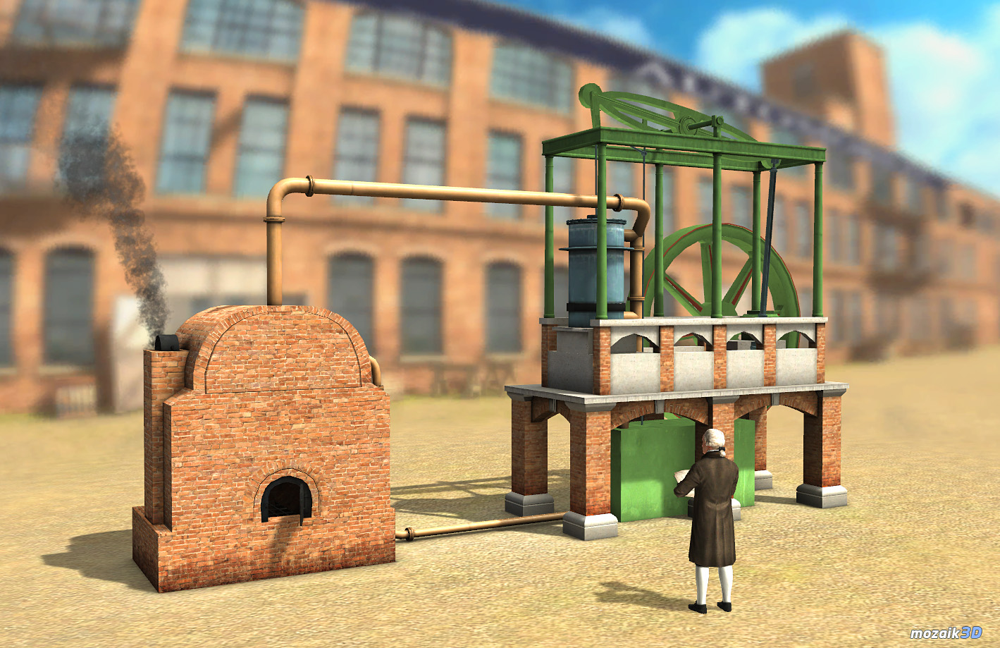
“The industrial revolution evolved in the island country in the 17-18th centuries. Several inventions were patented that diversified production. One of them was the steam engine perfected by James Watt.”
Applying Watt’s Steam Engine (18th century) mozaik3D Interactive model we can get familiar with the engine’s structure, with the operation of some of its parts and with circumstances of development. Let’s look at the narrated Animation first. Then, clicking on Edit we can drag the engine with our mouse and look at it in various views. In the toolbar above, if we click on rotate the image can be locked in any view. In this way, further drawings and texts can be added to make the material clearer for students.
When we right-click on the image a menu becomes available and here Task allows us to practise the names and location of each part. Let’s do the same on tabs Piston and Condenser. In the end, we may test our knowledge with the quiz in Exercise.
2. Now let’s introduce how the industrial cities and the working class came into existence.
“While England was about to become „the workshop of the world”, industrial towns were built and the working class was born: a new layer of society.”
Through applying a mozaik3D Interactive model named Working-Class District (19th century) we can look into the daily life of an average working class district.

After watching the Animation we can take a walk in the streets. Navigation is done through the mouse and right-left arrows. From the menu, we can reach Mining at the Time of the Industrial Revolution and Textile Factory (19th century) animations, too. If we still have time until the end of the lesson we should definitely show these to class. What we’ve learnt can be checked with a quiz in Exercise.
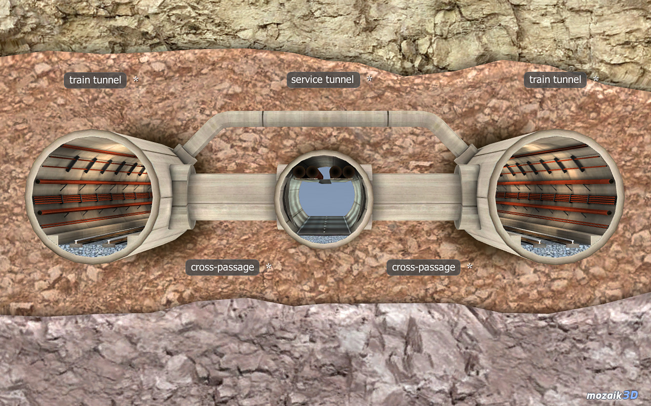
3. Let’s discuss the role that the Channel Tunnel played in the goods and passenger transaction among Great Britain and the Continent.
„The British Isles are separated from Europe with La Manche. The Channel Tunnel, completed in 1994, conducts an increasing proportion of the goods and passenger transaction between the continent and Great-Britain under the sea.”
To demonstrate the Channel Tunnel and the high-speed TGV trains in it, we can use the following mozaik3D Interactive models.

4. Let’s introduce the topographic location of major cities that were chosen based on geographic factors.
Using mozaMap Geography Atlas, we can teach about the British Isles:
- their topography and hydrography;
- their mineral wealth;
- their climate;
- heir agricultural territory;
- and their urban network.
While analysing the maps, we should try to figure out together those installation factors that assisted to the settlement of each city in particular spots. Besides, we can guess together the factors of their development and deterioration.
Methodology
- Subject: Geography
- Material: Geography of Europe / United Kingdom of Great-Britain and Northern Ireland
- Age Group: Primary school, students 12-13 years of age
- Skills: creative thinking, map reading, thematic maps, analysing diagrams, IKT competences
- MozaLearn tools used: mozaBook, mozaMap Geography Atlas, mozaik3D Interactive models: Watt’s steam engine, Working class district, The Channel Tunnel, TGV POS train
The goal of the lesson is to acquire knowledge of the following processes and relationships and also understanding them:
- The role of the Industrial Revolution and technical innovations in the development of traditional heavy industry sectors.
- Circumstances of how industrial cities and the working class came into existence.
- The role played by the Channel Tunnel in the good sand passenger trade among Great Britain and the Continent.
- The topographic location of major cities based on geographic factors.
Organisation: Computers are required as well as live internet connection.
Experiences:
The introduced tools and ideas can be exploited in various ways during the lesson to achieve a highly interactive class work. We may choose frontal teaching or to work individually but working in pairs or in teams are also possible. The processing method that we choose depends on the time frame available and the number of students within the class just as their motivation. E.g.: In case there is a longer time frame available with a smaller group, the material processed with certain models can be introduced in the form of small presentations to each other.